Wednesday, 10 December 2014

Lead on to Antarctica!

Roman pipes, Queen Elizabeth I's white make-up, HEAVINESS...there are many things that might spring to mind when you think about lead. But would you associate this element with Antarctica? I certainly didn't. But apparently lead found its way to the southern-most continent even before we did (McConnell et al., 2014).


Lead had reached Antarctica before Captain Roald Amundsen and
Captain Robert Falcon Scott famously raced to the South Pole in 1911...
Source: www.thesundaytimes.co.uk; Universal History Archive/Getty
Just as mercury is transported to the Arctic from the northern mid-latitudes (see last week's post), lead is transported to Antarctica from lower latitudes in the southern hemisphere (McConnell et al., 2014). 

In a study published earlier this year, McConnell et al. examined 16 ice cores across Antarctica in order to construct a 410 year record of lead pollution in the region. By looking at "lead concentration, enrichment and deposition flux", the authors were able to conclude that lead pollution existed in Antarctica as early as 1889, and that it still persists today (McConnell et al., 2014). 

By 1900, lead concentrations had reached up to 5.4 pg/g (compared to ~0.6 pg/g and ~1.8 pg/g in 1650 and 1885, respectively); 21st Century concentrations are lower, but still somewhat greater than pre-industrial levels (McConnell et al., 2014). Hmm...perhaps a different type of statistic would be easier to conceptualise: the authors estimate that ~660 tonnes of lead have been deposited on the continent over the last 130 years - that's pretty striking (McConnell et al., 2014). Not only that, but they can actually work out exactly where it's come from. Ooh. Grab your deerstalker, it's time for some detective work...


I've somehow managed to work Sherlock Holmes
into the post - I for one didn't see that coming. But seriously,
using isotopic ratios to trace the source of pollutants is good
detective work. Source: www.sherlock-holmes.co.uk
Isotopic ratios can tell us a lot about the source of lead pollution. By measuring Pb-206/Pb-207 isotopic ratios over time in nine ice cores, McConnell et al. (2014) were able to attribute the early lead pollution to just one source: the Port Pirie smelter in Australia. This site, which processes the Australian Broken Hill lead and silver ores, could be traced owing to the characteristically low isotopic ratio signature of the ore (McConnell et al., 2014). Interesting. Furthermore, the removal of lead from petrol in many countries in the southern hemisphere by 1996 could also be identified by looking at the ratios (McConnell et al., 2014).

Of course, there's more to Antarctic pollution than lead, just as there's more to Arctic pollution than mercury. But I was interested to investigate whether industrial pollution could also reach the interior of this vast, remote continent from the mid-latitudes, and this recent research provides evidence that it can.

Wednesday, 3 December 2014

Into the Arctic Haze...

How might increased Asian industrialisation lead to obesity in an Arctic indigenous population? Read on to find out!

                                                                    ----------------------------------------- 

Breathe in...breathe out...pure, clean, fresh Arctic air...mmmm...just what you want a bottle of when you're on the Tube. Yes?

Actually, it seems that the air in the Arctic might not be as detoxifying-ly lovely as I imagine it to be. Which is disappointing. It's also very worrying, in terms of the implications it holds for the Arctic ecosystem. 


The so-called 'Arctic haze' - which comprises particulate organic matter and sulphate, along with other compounds - is a tangible indication that all is not well with the Arctic atmosphere. Although it had been noticed previously, it wasn't until the 1970s that this mysterious smog was attributed to human industrial activities (Law & Stohl, 2007). But how does that work, when emissions in the Arctic region are relatively low? As discussed by Law and Stohl (2007), pollutants are transported to the Arctic from lower latitudes (such as Eurasia), where they then persist in the environment; the haze is particularly strong in the late Winter and early Spring when there is little precipitation to remove pollutants from the atmosphere. 


It's quite difficult to find a good picture of 'haze'! But I think this one does the job.
Source: www.redorbit.com
To be honest, we could be here for hours, talking about all the different components of the Arctic haze and their effects...Instead, let's focus on just one (but trust me, it's an important one): mercury.


Coal-burning is a major contributor to atmospheric mercury
pollution. Source: www.ft.com
While mercury is released into the environment via natural sources (for example through the weathering of rock and volcanic eruptions), it's no coincidence that emissions have risen steeply since the start of the industrial revolution (AMAP, 2011). Indeed, human activity accounts for approximately 30% of annual mercury emissions to the air (with an estimated 1960 tonnes released in 2010), compared to 10% from natural sources (UNEP, 2013). The remaining 60% can be explained by 're-emissions', the majority of which are also likely to be of anthropogenic origin (UNEP, 2013). Coal burning - which released 475 tonnes of mercury in a year (2010) - is an important source, however measures are being taken to reduce the amount of pollution produced during this process (UNEP, 2013). When looking at anthropogenic emissions, Asia is currently the largest contributor of mercury to the atmosphere, accounting for almost 50% (UNEP, 2013). Before I stop bombarding you with figures, it must also be remembered that mercury pollution is not restricted to the atmosphere: mercury concentrations in the top 100 metres of the ocean have increased two-fold over the last century owing to human emissions (UNEP, 2013).

So, although we intuitively know this probably isn't good for the planet, what does it actually matter? Well, seeing as this mercury is able to reach the Arctic in just a few days (when transported by air currents...it can take decades to be transported in the ocean), it has important consequences for the Arctic ecosystem (AMAP, 2011). 


A fluffy creature (or Vulpes lagopus to be more precise). Arctic
foxes are one of the species affected by mercury bioaccumulation.
Source: www.news.softpedia.com
Mercury can be found in many forms; in low oxygen environments (for example wetlands or the seabed) it is converted from an inorganic form to methylmercury, which is highly toxic (AMAP, 2011). Methylmercury is able to enter the food chain, where it then bioaccumulates, reaching levels in apex consumers that can be a million times greater than those in organisms at the bottom of the food chain (AMAP, 2011). This is obviously detrimental to these animals (which include the Arctic fox, polar bear and ringed seal), as demonstrated by the mercury-induced neurochemical effects observed in the toothed whale (Bocharova et al., 2013; AMAP, 2011). However, it also has implications for the Arctic indigenous populations that traditionally rely on these animals for food. In a problem known as the 'Arctic Dilemma', there must be a trade-off between the amount of mercury indigenous people are exposed to, and the nutritional benefits of these foods (AMAP, 2011). In order to limit their mercury intake, indigenous populations can be advised to eat alternative foods, but this can be damaging not only culturally but physically, since imported processed foods can increase the risk of heart disease and obesity...(AMAP, 2011).

So there we are, we've come full circle - that is how increased Asian industrialisation could lead to obesity in an Arctic indigenous population. 

Tuesday, 25 November 2014

Coming Up...

Right, so we've spent a little while looking at some of the impacts of climate change on the polar regions. It hasn't been the most cheery of topics I'll admit, but it's a very important one. Time for something a bit different... Hey, maybe it'll be more uplifting!

Here's a short video to whet your appetite:


That's right - pollution at the poles (hmm, maybe 'uplifting' was optimistic...we'll see!).

Thursday, 20 November 2014

Melting Permafrost - A Purely Arctic Problem?

Last week we looked at the potential consequences of melting Arctic permafrost, so this week - that's right, you guessed it - we'll be taking a trip down south to examine the future of Antarctic permafrost. 

Not how you usually think of Antarctica? These are the McMurdo Dry Valleys,
located in Southern Victoria Land. Source: https://thelastdegrees.wordpress.com.
Credit: INSTAAR, University of Colorado.
That's better, we were definitely due a beautiful Antarctic landscape photograph. After all, we have to remind ourselves what we're talking about. Importantly, however, this image shows the McMurdo Dry Valleys, one of the places where permafrost can be found on the continent.

Compared to the Arctic equivalent, Antarctic permafrost hasn't received much attention. Indeed, until recently there was little concern about its future. However, a study conducted by researchers at the University of Texas has suggested that permafrost dynamics may not be as stable as originally thought (Levy et al., 2013). Levy and his team used the "natural laboratory" of the Garwood Valley to investigate thermokarst formation, focusing specifically on the behaviour of one particular ice cliff (Levy et al., 2013). (As previously discussed, thermokarst landforms are unstable structures created through the melting of ground ice.) The ice cliff provides a useful study site - rate of erosion can be calculated relatively easily here, by measuring retreat with respect to a set reference point, and research has shown that the exposed ice is of an identical composition to that found within the valley floor (Levy et al., 2013). Through a combination of time-lapse imaging, ground-based LiDAR (a laser scanning technology), and a monitoring station positioned ~8 metres from the ice cliff, erosion rate was measured over a number of years (Levy et al., 2013). 

These were found to increase over time: between 2001-2002 and January 2012, erosion occurred at a rate of 5000±100m^3 per year; between January 2011 and January 2012 this had risen to 11,300±230m^3 per year, which is ten times the rate estimated for the late Holocene (1150±20m^3 per year) (Levy et al., 2013). So what's caused this increase in melt rate? Although increasing air temperatures may seem like an obvious answer, between 1986 and 2000 the Dry Valleys actually experienced a cooling of 0.7°C per decade (Doran et al., 2002). Instead, Levy et al. (2013) attribute the acceleration in melt rate to an increase in solar radiation, thought to be a result of changing weather patterns. Nevertheless, future temperature increase in the Antarctic would likely lead to a similar permafrost response.

While permafrost melt in Antarctica is arguably less of a concern to the general public than that taking place in the Arctic (where the infrastructure of communities is under immediate threat), this study highlights that it is an avenue of research that should be pursued. Levy et al. (2013) point out that thermokarst structure "down-valley" showed little - if any - change between 2009 and 2012; it would therefore be interesting to see if the Garwood Valley ice cliff is in fact representative of a wider region of permafrost, or whether it is responding to increased solar radiation in an unusual way.  

Right, after all that, here's another lovely picture (just because it's lovely):


This is the Canada Glacier, found in the McMurdo Dry Valleys (specifically, the
Wright Valley). Source: www.nsf.gov. Credit: Peter Doran; National Science Foundation.
Oh, and in case you were wondering, it looks like methane release from Antarctica might be an issue too...

Wadham et al. (2012) propose that Antarctic sedimentary basins contained approximately 21,000Pg of organic carbon when the ice sheets were forming. This knowledge, combined with the relatively recent discovery of microorganisms beneath the ice sheets (see Lanoil et al., 2009), shows the potential of this environment for methanogenesis (Wadham et al., 2012). A model produced by Wadham et al. (2012) suggests there could be a methane hydrate reserve beneath the East Antarctic Ice Sheet of 70 to 390Pg of carbon (equivalent to 1.31 to 7.28x10^14 cubic metres of methane) and "some tens" of Pg of carbon (equivalent to ~2x10^13 cubic metres of methane) underneath the West Antarctic Ice Sheet. Not much imagination is required to think what might happen to all this methane if the ice sheets recede...  

Interestingly therefore, in terms of permafrost melt and methane release, the Arctic and Antarctic share a lot more similarities than I originally thought. 

Thursday, 13 November 2014

Mystery at the 'End of the World'

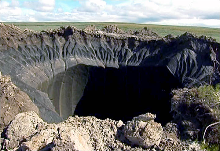
In July of this year, a large crater was spotted puncturing the Siberian landscape. Theories regarding its formation immediately appeared, ranging from suggestions of a metorite impact, to gas explosions, and even alien invasion.

So, I present you with a mystery: what caused this hole?

The 30 metre wide crater on the Yamal Peninsula, Siberia.
Source: www.siberiantimes.com
The crater is located on the Yamal Peninsula in Siberia ('Yamal' meaning 'end of the world' in the Nenet language), and is 30 metres wide (Moskvitch, 2014). While investigations are still ongoing (for example, exploration into the interior of the crater has only recently taken place, made easier by the frozen ground), scientists have found an explanation for the structure (The Siberian Times, 2014). Sorry, I haven't kept you in suspense for long.

Analysis has shown that air at the bottom of the crater has a methane concentration of 9.6%, compared to the usual 0.000179%, providing a large clue as to its origins (Moskvitch, 2014). When permafrost (soil, rock or sediment that remains frozen for at least two years) thaws, methane is released. It is thought that the methane released here was trapped underground by a layer of ice, leading to a build up of pressure, and subsequent explosion (Moskvitch, 2014). This is worrying, especially given the close proximity of the site to the Bovanenkovskoye gas field (Moskvitch, 2014).

While the enigma of the crater in itself attracted a lot of attention, the implications of this story for the rest of the Arctic are also deserving of some study.  


Map to show Arctic permafrost distribution. Darker shading represents areas with
a greater percentage of permanently frozen ground. Source: www.nsidc.org

During the summers of 2012 and 2013, the Yamal Peninsula experienced unusually high temperatures (~5°C above average (Moskvitch, 2014)). While some believe this to be the cause of the permafrost thaw in the region, others attribute the large amount of methane released to long-term global warming (Moskvitch, 2014). Indeed, it has been suggested that permafrost temperatures rose by as much as 6°C over the course of the 20th Century (NSIDC, 2014). As shown by the map above, permafrost covers a significant area of ground in the Arctic region (to be more specific, ~22.79 million square kilometres), making this a large-scale issue (NSIDC, 2014). 


Coastal erosion during a ("not...particularly strong" - NSIDC) storm
in Shishmaref, Alaska, 2003. A combination of sea ice decline and
permafrost melt have led to this erosion.These photos were taken only
two hours apart; the barrel can be used for reference.
Source: www.nsidc.org; Tony Weyiouanna, Sr.
As discussed by Rowland et al. (2011), it can be difficult to model the response of the Arctic ecosystem to permafrost thawing, owing to the complexity of the potential feedback mechanisms involved. For example, loss of permafrost can lead to drying of the substrate surface, increasing fire risk (Rowland et al., 2011). A fire would in turn alter the albedo of the land surface, leading to more permafrost warming and thawing (Rowland et al., 2011). However, some likely consequences of permafrost degradation have been suggested. Permafrost contains both ground ice and massive ice (basically just large blocks of ground ice). When massive ice melts, voids are left in the ground, making it unstable. This can lead to erosion and the creation of thermokarst (an irregular land surface formed through subsidence), causing problems for Arctic communities (Rowland et al., 2011). Increased sediment from erosion of river channels could have implications for Arctic fisheries, and permafrost melting also alters soil permeability, changing surface water flow (Rowland et al., 2011). This list is not exclusive, but gives an indication of the sorts of issues that may arise as a result of permafrost melt.

Of course, although I want to focus on the Arctic specifically today, it would be impossible to finish without mentioning the potential global impact of melting permafrost. What was the cause of the explosion that created the Siberian crater? Methane. According to Anthony et al. (2012), "the Arctic geologic methane reservoir is large", "with a carbon store of over 1200Pg". This figure is particularly striking when compared to the 5Pg store of the atmospheric methane reservoir (Anthony et al., 2012). When permafrost melts, methane can be released via physical or biological processes: through the release of methane clathrate, or decay of organic matter, respectively. It is thought that microbial processes will be of fundamental importance in the transfer of carbon to the atmosphere (Schuur et al., 2008), but further research is needed before they can be fully understood (see Graham et al., 2012). It has been estimated that thawing permafrost may release as much as 100Pg of carbon into the atmosphere by the end of the century (Schuur et al., 2008). Methane is a more potent greenhouse gas than carbon dioxide, and its release would lead to positive feedback cycles as increased warming caused more permafrost to melt. As such, media coverage on this topic seems to be increasing, with the situation often being referred to as a 'time bomb'...


Wednesday, 5 November 2014

People and the People

Well, it looks like November has well and truly arrived; I swear it got dark at 3 o'clock yesterday. Then again, in Iqaluit (Nunavut, Canada), the sun actually did set at 3.10pm, so I suppose I shouldn't really complain...

Anyway, I'm getting distracted. Over the last couple of weeks we've begun to see how climate change is impacting upon the polar regions, specifically looking at trends in sea ice extent. I think there's a certain naivety surrounding this topic, in that it's easy to assume these two areas - both vast white wildernesses - are going to respond to climate change in the same way. This may be true to some degree, but I hope the sea ice example has demonstrated that the complexity of these systems, and the differences between them, should not be underestimated. 

Before we examine some of the other ways in which humanity is impacting upon the polar regions, we're going to briefly look at the consequences of changing sea ice levels for those experiencing them first-hand. Since no one permanently lives in Antarctica (another difference between the two regions), we'll be seeing how sea ice decline is affecting Arctic Indigenous Peoples. 

Inuit hunting with a bow and arrow. Source:
www.firstpeoplesofcanada.com
People have made their home in the Arctic for thousands of years, with indigenous populations including the Saami, Chukchi and Inuit. However, recent climatic changes - including a thinning and loss of sea ice - are threatening their way of life. 

As previously discussed, sea ice extent was at a record minimum in 2012. During this year, the spring narwhal hunt of the Inuit community living on the north coast of Baffin Island provided only three animals, compared to the usual ~60 (Struzik, 2012). The reduced thickness of the sea ice rendered it unsafe to walk on (a necessity for a successful hunt), and more open water attracted killer whales to the area, scaring off the narwhals (Struzik, 2012). This particular example highlights two of the main consequences of sea ice decline: increased danger resulting from thin, unstable ice, and changes to Arctic species distributions. 

As just mentioned, some species - such as the killer whale - are expanding into new Arctic regions as a result of ice loss (Higdon & Ferguson, 2009). However, changing ice conditions are limiting the distribution of other animal populations, rendering them inaccessible to hunters. For example, a decline in the number of walruses near Igloolik (Nunavut, Canada) has led to food shortages amongst the Inuit community that lives here (Arctic Council, 2013). Hunters are having to travel increasing distances to find food, and may now have to employ alternative hunting methods (such as hunting from a boat rather than from the ice) (NSIDC, 2014). 

Declining sea ice has also led to an increasing number of storms, which poses a safety risk to hunters, and can also cause coastal erosion (NSIDC, 2014). Furthermore, the weather has reportedly become less predictable (Ford et al., 2008). Combined with the danger associated with thinner, less stable ice, it is clear that sea ice decline in the Arctic is making life here more hazardous.

Finally, it is important to remember that physical changes in the Arctic - and the consequences that arise from them - are threatening the cultures of indigenous populations. Ford et al. (2008) write "the procurement, sharing and consumption of traditional food contributes significantly to cultural identity, tradition and social cohesion". Changes in hunting techniques, and redundancy of methods used for weather prediction, may contribute to a loss of identity in these societies. 


Friday, 31 October 2014

A Genuinely Scary Hallowe'en...

If you've ever enjoyed a night out trick-or-treating, spare a thought for the children of Arviat, Canada, who have been told to stay indoors this Hallowe'en. Why? It's all to do with the shrinking Arctic sea ice...click here to find out more. 


This image was captured in Arviat, Canada...a big clue as to why children
aren't allowed out this Hallowe'en. Source: www.slate.com